
10th Standard Syllabus & Materials
10th Standard
TN 10th Social Science ECO - Industrial Clusters in Tamilnadu - New Important Questions And Answers Study Material - QB365 Set A
NEW10th Standard
TN 10th Social Science ECO - Government and Taxes - New Important Questions And Answers Study Material - QB365 Set A
NEW10th Standard
TN 10th Social Science ECO - Food Security and Nutrition - New Important Questions And Answers Study Material - QB365 Set A
NEW10th Standard
TN 10th Social Science ECO - Globalization and Trade - New Important Questions And Answers Study Material - QB365 Set A
NEW10th Standard
TN 10th Social Science ECO - Gross Domestic Product and its Growth : an Introduction - New Important Questions And Answers Study Material - QB365 Set A
NEW10th Standard
TN 10th Social Science CIV - India's International Relations - New Important Questions And Answers Study Material - QB365 Set A

Published on: 22/10/2025
Download Tamil Nadu 10th Standard Social Science question papers, model tests, one-mark questions, important questions, and public exam papers in PDF format. Free study materials and answer keys for TN State Board students.
Questions + Answers key
Take MCQ Social Science Test
1.
India’s life expectancy at birth is ______ years.
65
60
70
55
2.
India is ______ larger producer in agricultural product.
1st
3rd
4th
2nd
3.
4.
_________ is not a part of the world network biosphere reserves of UNESCO.
Nilgiri
Agasthiyamalai
Great Nicobar
Kachchh
5.
______________ is a line joining the places of equal rainfall.
Isohyets
Isobar
Isotherm
Latitudes
6.
_________ helps in quick ripening of mangoes along the coast of Kerala and Karnataka.
Loo
Norwester
Mango showers
Jet stream
7.
Western disturbances cause rainfall in _____.
Tamilnadu
Kerala
Punjab
Madhya Pradesh
8.
_______ Plains are formed by the older alluviums.
Bhabar
Tarai
Bhangar
Khadar
9.
The Palk Strait and Gulf of Mannar separates India from ______.
Goa
West Bengal
Sri Lanka
Maldives
10.
_________ River is known as ‘Sorrow of Bihar’.
Narmada
Godavari
Kosi
Damodar
11.
What is per capita income?
12.
Write the importance of Gross domestic product.
13.
Define National income.
14.
Write a short note on ‘Monsoon wind’.
15.
What are ‘jet streams’?
16.
State the west following rivers of India.
17.
Give the importance of IST.
18.
What are the methods of calculating Gross Domestic Product? Explain its.
19.
Describe the forests of India.
20.
Give a detailed account on the basin of the Ganga.
21.
22.
Weather and Climate.
23.
Western Coastal Plains and Eastern Coastal Plains.
24.
Mountains are cooler than the plains.
25.
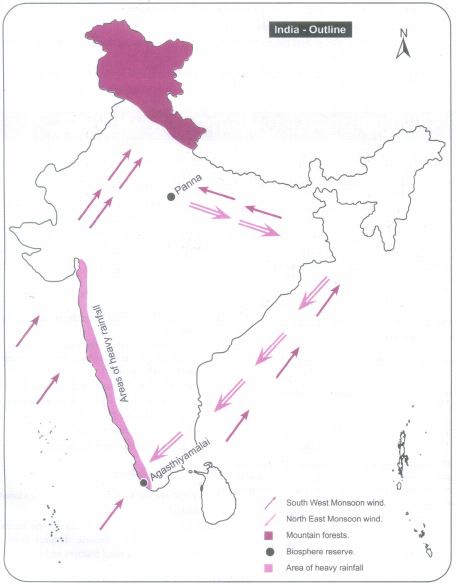
Mark the following on the outline map of India.
1. Direction of South West Monsoon wind.
2. Direction of North East Monsoon wind.
3. Areas of heavy rainfall.
4. Mountain forests.
5. Panna biosphere reserve
6. Agasthiyamalai biosphere reserve
1.
(a)
65
2.
(d)
2nd
3.
(b)
4.
(d)
Kachchh
5.
(a)
Isohyets
6.
(c)
Mango showers
7.
(c)
Punjab
8.
(c)
Bhangar
9.
(c)
Sri Lanka
10.
(c)
Kosi
11.
Per Capita Income (PCI) or output per person is an indicator to show the living standard of people in a country. It is obtained by dividing the national income by the population of a country
\(\text {Per capita Income } = \frac { \text { National Income }}{\text { Population }} \)
12.
i) Study of Economic Growth
ii) Problems of inflation and deflation
iii) Comparison with developed countries of the world
iv) Estimate the purchasing power
v) Study of Public Sector
vi) Guide to economic planning
13.
i) 'National Income is a measure of the total value of goods and services produced by an economy over a period of time, normally a year'.
ii) National Income is called as Gross National Product (GNP) or National Dividend.
14.
a) The most dominant factors which affects the climate of India is the monsoon winds.
b) These are seasonal reversal winds and India remains in the influence of these winds for a considerable part of a year.
c) The onset of southwest monsoon brings down the temperature of the entire India and causes moderate to heavy rainfall in many parts of the country.
d) Similarly, the climate of southeast India is also influenced by northeast monsoon.
15.
a) Jet streams are the fast moving winds blowing in a narrow zone in the upper atmosphere.
b) According to the jet stream theory, the onset of southwest monsoon is driven by the shift of the subtropical westerly jet from the plains of India towards the Tibetan plateau.
c) The easterly jet streams cause tropical depressions both during south-west monsoon and retreating monsoon.
16.
Narmada, Tapti, Mahi and Sabarmathi are the west following rivers of India.
17.
The longitudinal difference between Gujarat in the west and Arunachal Pradesh in the east is about 30°. Since Arunachal Pradesh is towards east. it will have sunrise about two hours earlier than the sunrise at Gujarat which is in the west. In order to avoid these differences, Indian Standard Time is calculated. The IST is 5.30 hrs ahead of Greenwich Mean Time (GMT).
18.
Synopsis:
a) Expenditure Approach
b) The income Approach period.
c) Value added Approach
a. Expenditure Approach:
In this method GDP is measured by adding the expenditure on all the final goods and services produced in the country during a specific period.
Y= C + I + G + (X - M)
b. The income Approach:
In this method GDP is calculated from the perspective of the earnings of the men and women who are involved in producing goods and services.
Y = wages + rent + interest + profit
c. Value added Approach:-
In this method GDP is calculated by including the values of intermediate goods to estimate the value of final goods.

19.
On the basis of climate, soil and land form characteristics the natural vegetation of India can be divided into the following types.
Tropical Evergreen Forest:
i) These forest are found in areas with 200 cm or more annual rainfall.
ii) Western Ghats in Maharashtra, Karnataka, Kerala, Andaman Nicobar Islands, Assam, West Bengal, Nagaland, Tripura, Mizoram, Manipur and Meghalaya states have this type of forests.
iii) The most important trees are rubber, mahogany, ebony, rosewood, coconut, bamboo, cinchona, candes, palm, iron wood and cedar.
Tropical Deciduous Forest:
i) These forests are found in the areas with 100 to 200 cm annual rainfall.
ii) These are called 'Monsoon Forests'.
iii) The trees of these forests drop their leaves during the spring and early summer.
iv) These forests are found in Punjab, Haryana, Uttar Pradesh, Bihar, West Bengal, Jharkhand, Madhya Pradesh, Chhattisgarh, Maharashtra, Telangana, Andhra Pradesh and Tamil Nadu.
v) Teak and Sal are the most important trees. Sandal wood, rose wood, Kusum, Mahua, Palas haldu, amla, padank, bamboo and tendu are the other trees of economic importance.
vi) These forests also provide fragrant oil, varnish, sandal oil and perfumes.
Tropical Dry Forest:
i) These forests are found in the areas with 50 to 100 cm annual rainfall.
ii) They represent a transitional type of forests.
iii) These are found in east Rajasthan, Haryana, Punjab, Western Uttar Pradesh, Madhya Pradesh, Eastern Maharashtra, Telangana, West Karnataka and East Tamil Nadu.
iv) The important species are mahua, banyan, amaltas, palas, haldu, kikar, bamboo, babool, khair, etc.
Tropical Thorn Forest:
i) These are found in the areas having annual rainfall of less than 50 cm.
ii) They have low humidity and high temperature.
iii) These forests are found in north - west India, which includes west Rajasthan, South west
iv) Haryana, North Gujarat, South - west Punjab, parts of the Deccan plateau in Karnataka, Andhra Pradesh and Maharashtra.
v) Babul, Kikar and Wild palms are common trees found here.
Mountain or Montane Forest:
On the basis of altitude and amount of rainfall, these forests are classified into two.
i) Eastern Himalayan Forest,
ii) Western Himalayan Forest.
Alpine Forest:
i) It occurs all along the Himalayas with above 2400 m altitude.
ii) These are purely having coniferous trees.
iii) Oak, silver fir, pine and juniper are the main trees of these forests.
iv) The eastern parts of Himalayas have large extent of these forests.
Mangrove Forest:
i) These forests occur in and around the deltas, estuaries, creeks, prone to tidal influences and as such are also known as delta or swamp forests.
ii) The delta of the Ganga, Brahmaputra has the largest tidal forest.
iii) These are also known as Sundarbans forest.
iv) The deltas of Mahanadi, Godavari and Krishna rivers are also known for tidal forests.
v) These are also known as tidal forests.
20.
i) The river Ganga originates as Bhagirathi from the Gangotri Glacier in Uttar Khasi district of Uttarakhand state.
ii) The length of the river Ganga is about 2,525 km.
iii) Its major tributaries from the north are Gomti, Gandak, Kosi and Ghaghara.
iv) Its tributaries from south are Yamuna, Son and Chambal. The largest of its tributaries is the Yamuna.
v) The Ganga river system is the largest drainage system in India. It extends over an area of 8,61,404 sq km in India.
vi)The Ganga plain is the most densely populated place in India.
vii) The river Ganga is known as the River Padma in Bangladesh.
viii) The combined river of Ganga and Brahmaputra creates the World's largest delta known as Sundarbans in Bangladesh before joining the Bay of Bengal.
21.
22.
| S.No. |
Weather |
Climate |
|---|---|---|
| 1. | Weather refers to the state of atmosphere of a place at a given point of time. | Climate is the accumulation of daily and seasonal weather event of a given location over a period of 30 - 35 years. |
| 2. | Weather of a place may change daily. | Climate of a place remains constant over a long period. |
23.
| S. No |
West Coastal Plains |
East Coastal Plains |
|---|---|---|
| 1. | Western coastal plains lies between the Western Ghats and the Arabian sea. | Eastern coastal plains lies between the Eastern Ghats and the Bay of Bengal. |
| 2. | It extends from Rann of Kutch in the north to Kanyakumari in the south. | It extends from Bengal in the north and Tamilnadu in the south. |
| 3. | The short swift rivers do not make any deltas on the coast. | The large rivers make wide deltas on the eastern coastal plain. |
| 4. | Characterised by sand beaches sand dunes and lagoons. | Formed by the alluvial fillings of the littoral zones by the east flowing rivers. |
| 5. | The northern part of this coast is called the Konkan coast and the southern part is called the Malabar coast. | The northern part of this coast is called North circars and the southern part is called Coromandel coast. |
24.
When the altitude increases the temperature decreases. Temperature decreases at the rate of 6.5°C for every 1000 metres of ascent. Hence mountains are cooler than the plains.
25.

10th Standard Syllabus & Materials
10th Standard
TN 10th Social Science CIV - India's Foreign Policy - New Important Questions And Answers Study Material - QB365 Set A
NEW10th Standard
TN 10th Social Science CIV - State Government - New Important Questions And Answers Study Material - QB365 Set A
NEW10th Standard
TN 10th Social Science CIV - Central Government - New Important Questions And Answers Study Material - QB365 Set A
NEW10th Standard
TN 10th Social Science CIV - Indian Constitution - New Important Questions And Answers Study Material - QB365 Set A



Tamilnadu Stateboard 10th Standard Subjects
Tamilnadu Stateboard Standards